Saturday, February 6, 2016

FIRST CALL ON THE EARLY WEEK SNOWSTORM

Another big headache is in the forecast for not only people that have to travel early this week, but also the forecasters themselves. At the same time, for snow lovers, things are getting a bit more interesting for the possibility of a more significant snowfall.

A clipper system will pass through the region, beginning Monday afternoon, as the snowfall will spread from West to East.
The image above is valid Monday Evening. Snow should start to fly in the air over Dauphin County after 4 PM Monday and will continue, steady at times, through late Tuesday Night and possibly even into early Wednesday Morning.

There will be lulls in the action at times, but this will technically be a 24 hour snowstorm. The lulls and light snowfall rates, will help keep totals from being "epic". If you are reading this from south of Baltimore through Southern New Jersey, rainfall mixing in will keep totals down.

There will be a "wild card" in this snowstorm. There will be an Inverted Trough involved, in English, there will be an area that receives a consistent period of heavy snowfall for several hours. Where this sets up, determines who can see double digit snowfall totals. Because it is 48 hours from the start of this storm, it is too early to determine where exactly the Inverted Trough sets up. Inverted Troughs are extremely hard to predict and we will likely not know where it will set up until about 12 hours prior to the storm occurring.

With that being said, here's the first look at my predicted snow totals:

Region A: 5 to 8 inches of snowfall expected.
Region B: 2 to 5 inches of snowfall expected.
Region C: Less than 2 inches of snowfall expected.
My forecasts Tomorrow and Monday will include where the Inverted Trough may setup. Right now I have too low of confidence to included the Inverted Trough.

I will leave you with this snow lovers, the latest GFS shows the Inverted Trough setting shop right over SCPA and Southeast PA.
Verbatim the GFS would be a 10 to 15 inch snowfall for Dauphin County. That is not my forecast, as my forecast is only for 2 to 5 inches, however this shows you all what the Inverted Trough can do to the snow totals we eventually end up with.

If you don't have my page liked on Facebook, please give it a like: Dauphin County Weather Facebook page!

-Chris 

Thursday, February 4, 2016

Sneaky Snowstorm For Some

 A sneaky snowstorm that I mentioned earlier this morning in my video will impact Eastern areas of PA/NJ/DE/MD/Long Island..and the storm has trended so far Northwest that even portions of SCPA may wake up to a coating of snowfall Tomorrow Morning.

For the whole coverage area, snow will break out after 3 AM and last through Noon.

Region A: Snow showers are possible...this has the chance of clipper Southeast Dauphin County. No accumulation is expected in this zone.

Region B: A coating to 1 inch of snowfall is expected.

Region C: 1 to 3 inches of snowfall is expected.

Region D: 3 to 6 inches of snowfall is expected.

Due to the timing of this storm, expect school delays and even cancellations for those East of our area. If you have any plans to the coastal regions, I would avoid travelling until at least Saturday if you are able to.

Early next week..Mon-Wed time-frame offers a better chance of a more widespread, possibly significant snowfall to the mid-state. More details on that coming Tomorrow.

-Chris


Monday, February 1, 2016

Warmth and Flooding This Week, Two Winter Storms Possible Next Week.

Over the last week or so, the melting process from the historic snowstorm has been quite steady, which is good news. However, most locations around the area still have anywhere between 6 and even 12 inches of snowfall on the ground, and of course those huge snow piles in parking lots and on the side of the roads. This gets the attention to forecasters out there because Wednesday will not only feature temperatures approaching the upper 50s to even 60 degrees, in some locations out ahead of a cold front, it will also feature a period of heavy rain and even thunderstorms. Because of this, the National Weather Service out of State College has issued a FLOOD WATCH which is in effect from Wednesday Afternoon through Thursday Afternoon. River flooding should not be an issue, but smaller creeks and streams may flood over their banks significantly, especially in flood prone areas.

Wednesday High Temps:
Don't be fooled in the image, many of us already peaked to near 60 degrees West of the Susquehanna River. In that particular image, the Cold front is sitting right over our region.

Here is a look at the rainfall valid 1 PM Wednesday:
Notice the oranges and reds...that is indicating embedded thunderstorms along this cold front, which will lead to bursts of heavier rain and potentially damaging winds. The showers will arrive here between 4 AM and 7 AM Wednesday Morning and last until about 4 PM. The worst of the rain will be between 10 AM and 2 PM. Rainfall totals will be in the 1 to 2 inch range, with pockets of 3 inches.

My attention then turns to next week, where I am beginning to see the possibility of two separate Winter Storms occurring, one being Monday Night (2/8) into Tuesday (2/9) and another storm late Wednesday (2/10) into Thursday (2/11).

For the first storm, a low pressure will be developing in the Southeast, and will try to make the turn up the coast. Whether it tracks right over us, versus a couple hundred miles offshore makes a huge difference whether we see rain, snow, or nothing at all. The latest GFS is the "Middle ground" solution currently. The image below is valid for late Monday Night.
Verbatim, the Lower Susquehanna Valley would be talking about a plow-able snowstorm. Nothing like the blizzard, however still a significant amount. The Canadian model has a low pressure tracking further inland, and delivers rain to our area, while places like State College and northward see accumulating snowfall. The European model keeps the system far enough offshore, we just see some light snowfall, turning to a light rainfall. If I had to put percentages out, I would say 70% for a storm, 30% for no storm.

Our next storm potential comes just a day later...guidance is split right now whether another low pressure creeps up the coast out of the Gulf of Mexico, or a clipper system redevelops and rapidly deepens somewhere in the Northeast. At this point, it is hard to talk about this storm with specifics, but this storm has better potential of delivering a more significant punch...but as it stands right now, it looks like areas further inland, and North as well have the better shot at seeing a substantial Winter Storm from this system than we do. A lot will change over the next 9 days...for snow lovers, you never want to be in the bulls-eye 9 days out.

The latest GFS right now is hinting at a period of snow for the second storm, but it is rather on its own for now with this solution.
That image is valid for Wednesday Afternoon. Like I said previously, guidance is really split on that storm. The upper air pattern would favor a track inland..near I-95, which would put our area right on the rain/snow line..so that's my preliminary thoughts regarding that system.

Summary: High temps of near 60 degrees and heavy rains Wednesday will lead to moderate and even significant flooding for some areas. Next week features two Winter Storm chances..Late Monday/Tuesday...and Wednesday/Thursday. This will be a long week of tracking, so make sure you keep it here.

Don't forget to like my Facebook Page-----> Dauphin County Weather Facebook Page!

-Chris 

Wednesday, January 20, 2016

2nd Call On The Major Winter Storm Friday Night through Saturday

We are now a little over 48 hours away from a major Winter Storm impacting the Mid-State. Latest guidance continues to key on our area for a significant snowfall.

Last night, I was concerned that our area might escape the significant snowfall because the European Model and it's Ensembles were keeping the heaviest precip south of the region. Well the latest run now pushes the heavier precip back into our neck of the woods.

Take a look at the comparison of the European Ensemble mean from last night vs Today's run.
Click on the image to zoom in...notice the darker greens how much further they make it up into PA than last night. This is a great sign for snow lovers.

However, there is still some worries out there. With this storm, there will be a severe cut-off. For example, Southern Dauphin has the chance to double those amounts in Northern Dauphin County if things set up like they potentially could. We will not know until the storm is crawling up the coast. This will be a very important now-cast situation.

GFS shows this cut-off well, however it is far enough North, that all of Dauphin County survives the cut-off.
Regardless, I do not see us getting away with absolutely no snowfall. I would be worried if lived near the State College area, rather than Harrisburg.

With all that being said, here is my latest thoughts.

Region A: Best chance to see 20 or more inches of snow.
Region B: 14-20 inches of snowfall is expected.
Region C: 8-14 inches of snowfall is expected.
Region D: 4-8 inches of snowfall is expected.
Region E: Coating to 4 inches of snowfall is expected.


TIMING: SNOWFALL WILL BEGIN AFTER 9 PM FRIDAY AND LAST THROUGH THE DAY SATURDAY. SNOWFALL WILL NOT TAPER OFF UNTIL MIDNIGHT SUNDAY.

Be sure to like my page on Facebook for the latest ---> DAUPHIN COUNTY WEATHER FACEBOOK PAGE!
-Chris

Sunday, January 17, 2016

Major Winter Storm On The Way?

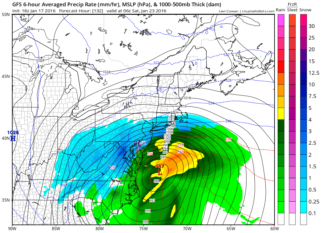
Alright before I get started here, I am going to show you a model by model breakdown of exactly what each of the three main weather models are showing for Friday (1/22) and Saturday (1/23).

A storm will gather its energy near Colorado mid-week, before taking a track towards the Gulf of Mexico. This allows the low pressure to gather more moisture from the Gulf of Mexico before taking a track to the Northeast. In other words...a classic track for a Winter Storm.

Latest GFS:
GFS has a major storm sitting off the coast of Virginia early Saturday Morning. The latest run is just south enough to keep us out of the epic snows, however, compared to its previous run, this run was a big improvement. Verbatim, the GFS would lead to a 6-12" snowstorm, 6" for Northern Dauphin, 12" for Southern Dauphin. Again that is verbatim..not a forecast. Epic snows remain south of the Mason Dixon line, where areas near DC and Baltimore see 12-20" of snow.

Next up the Canadian:
The Canadian model has the major storm about 100 miles Northwest of where GFS has it. Again this is early Saturday Morning. Verbatim, the Canadian would bring epic snows to the Mid-State, while areas South and East of I-95 have mixing issues. Verbatim, this model would bring 14-20" to all of Central and Eastern PA.

Lastly we have the European Model:
I know it is not as easy to see, however it has a similar look to the Canadian model, but instead a colder solution with the low pressure sitting about 50 miles further East. This again would bring epic snows to the Mid-State. Verbatim this would lead to a 16-22" snowfall, with the Laurel Highlands approaching a whopping 30".

Summary: All models are indicating a major storm Friday Afternoon into Saturday. GFS keeps epic snows south, while still delivering 6-12" of snow, CMC and Euro are both epic solutions, delivering 14-22" of snow verbatim.

My thoughts? It is a wait and see kind of game for me. I laid it all out on the playing for you guys to see what I am looking at. PLEASE DO NOT TELL OTHERS "A BIG SNOWSTORM IS COMING THIS WEEKEND." Just wait until Tuesday before declaring that. A lot can and will change. However, I will say I like what I see for you snow lovers out there.

P.S. Find your yard sticks everybody....just kidding...for now.

If you see this article, then like my Facebook Page for updates regarding this potential Major Winter Storm: Dauphin County Weather Facebook Page!

-Chris

Thursday, January 14, 2016

Big Storm This Weekend Will Lead To More Rain

Beginning early Saturday Morning, while most of us are sleeping, rain will begin to develop from the South. There will be two separate lows to track, one, a low pressure that cuts through the Great Lakes into Canada, and another low that forms a significant coastal storm.

IF we did not have the low pressure in Southeast Canada and just had the coastal storm we would be talking about a significant snowstorm for our region. However, thanks to the low in SE Canada, warmer air is able to sneak into the region, helping this storm deliver rainfall.

Take a look at the latest GFS valid early Saturday Morning:
Whether the coastal storm takes a track closer to the coast, or further away from the coast will determine how much rainfall the Mid-State sees. If it takes a track to the right, we get brushed, if it takes a track to the left, we are in for a washout. I am favoring closer to the left track, unfortunately.

Rainfall amounts will range from 0.5 inches to 1.5 inches. All rain should be out of the region by Saturday Evening.

When is our next chance for snow? Monday may offer some light snow showers, not looking too promising at the moment. Another potent storm is brewing between the 21st and 23rd. Too far out for details, but again, the trend this Winter for big storms, is for them to produce rainfall...

Do not forget to like DCW on Facebook: Dauphin County Weather Facebook Page!

-Chris

Monday, January 11, 2016

Final Call Map On Tomorrow's Clipper...Big Storm Looming For The Weekend?

No surprise here, a Clipper is on its way to deliver a light snowfall for many of us. Over the last 24 hours, I am becoming increasingly concerned that rather our area see a period of light steady snow, we see a line of squalls form. These snow squalls may deliver blinding snow for a period of 10 to 20 minutes then it is gone. If your local town receives one of these intense snow squalls, there is no doubt in my mind areas may over-perform in terms of accumulation. It is simply a wait and see game to see who gets what at this point.

The latest NAM model shows the line of squalls forming to our West quite well.

Timing: The timing has sped up a little bit. Some light snow showers are possible between 10 AM and 2 PM. A heavy Snow Squall line may whip through the area between 2 PM and 6 PM, deliver with it our accumulating snow.

There is still a chance that the mountains "eat up" a lot of the precipitation before making it to Dauphin County, however I still think enough squalls survive the mountains for many of us too see flakes flying in the air. For my final call map, I trimmed the Coating to 1 inch area a bit on the southern edge. Nothing else has changed.

Yes folks, there will be a big storm this weekend. As of right now, it is an all rain event for everyone in PA..that is how I see it at the moment. Timing would be Saturday Morning through Saturday Night. Here is the setup.

In the picture below, you will a low pressure cut up through the Ohio Valley, this low pressure then dies out and reforms a second low off the coast of Jersey, then heads Northeastward from there.

In order for our area to see snowfall, we want the primary low cutting up through the Ohio Valley to die out over the state of Kentucky, then transfer off the coast of Southeast Virginia. If this occurs, which is not looking likely at the moment, a significant snowfall would be possible across the Mid-State.

We still have a good 4 days for this storm to trend colder, but as of now it is another rain maker. So snow lovers, make sure you appreciate every flake that falls Tomorrow...keep your fingers crossed for the weekend.

With a big storm coming this weekend, make sure you have my page liked on Facebook ---> Dauphin County Weather Facebook Page!

Thanks in advance. -Chris